
Enhancing Emergency Response With Advanced DroneWays Drone Technology
Search & Rescue Drone Services – Fast, Accurate & Mission-Ready Support by Drone Ways
"Schedule An Instant Appointment Booking With DroneWays"
Our Search & Rescue Capabilities

Live Video Streaming to Command Centers
High-definition live feeds
GPS tagging of sightings
Real-time flight path tracking
Multi-stakeholder communication
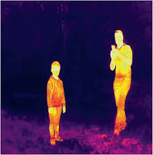
Night-Time and Low-Visibility Operations
Night searches
Fog and smoke conditions
Low-light environments
Overcast or stormy weather scenarios
Disaster Assessment & Situation Awareness
Flood mapping
Landslide assessment
Fire perimeter monitoring
Building collapse evaluation
Navigation of unstable terrain
Payload Delivery for Emergencies
Life jackets and First aid kit
Communication devices
Food & water
Emergency supplies


At DroneWays, We Do Thorough Search Until they Are Rescued.
Why Choose DroneWays
More Than Drone Shots We Deliver
Insights That Drive Progress.
Here’s what makes us different from just another drone service provider:

Certified Expertise
Our pilots are licensed professionals with deep experience in aerial mapping, surveying, and data management.

Precision Technology
We use the latest drone systems and sensors to ensure centimeter-level accuracy in every project.

End-to-End Solutions
From flight planning to data analysis, DroneWays manages the full process — so you can focus on your goals.

Transparent Reporting
Get clear visuals, measurable data, and easy-to-read analytics you can trust for real decisions.
Our success is measured by how clearly you see yours.
Why partner with DroneWays?
Choosing Drone Ways means choosing reliability, expertise, and quality.
Certified & insured drone pilots
Professional-grade equipment
Transparent safety procedures
Fast turnaround on reports & deliverables
Customizable data outputs
Competitive pricing
Dependable customer support
Ready to Start Your Project?
Whether you’re planning an inspection, survey, or specialized operation, Drone Ways is ready to help.
At DroneWays, we deliver precision, innovation, and data-driven drone solutions — from mapping and surveying to 3D modelling and aerial inspections.
Our Services
Drone Mapping
Aerial Surveying
3D Modelling
Data Analytics
Consultation